|
|
|
|
|
|
|
|
|
|
|
Caesarea
Philippi |
|
Caesarea Philippi was a town located near the northern boundary of the land of Israel. Often confused by modern readers with the other Caesarea (Maritima) located on the Mediterranean coast; it was a far less prominent locale, about 4 miles (6 km) east of Dan and 25 miles (40 km) north of the Sea of Galilee. Close to the foot of Mount Hermon (about 1150 feet, or 350 meters, above sea level), it is an area of lush grasslands and trees, with plenty of water as one of the sources of the Jordan River. Here, a massive spring flows out of the rock - its abundant supply of water made the area attractive for farming and religious purposes.
Spring-fed source of the Jordon River. Grotto of Pan in background.
An amazing amount of water pours out of the rock here! There is evidence that pagan worship took place in this area from ancient times. The Canaanites, who inhabited the land prior to the return of Israel from Egypt, worshipped numerous false-gods - with the area surrounding Mt. Hermon having sacred connotation. A specific location mentioned during the conquests of Joshua includes one near Mt. Hermon which is thought to be an ancient Canaanite name for Caesarea Philippi: Baal Gad...
Israel did not maintain control of this area throughout a significant portion of its history - of course, especially following the fall of the northern kingdom. During inter-testament times numerous pagan and political influences shaped the area, including the Greeks and Egyptians. A major battle at this location in 198 B.C. (the Battle of Panium), following the death of Alexander the Great, saw Antiochus III (called "the Great" as well. Ruled circa 223-187 B.C) defeat the Egyptians (Ptolemaic rule) and take control of the land of Israel for the Seleucids.
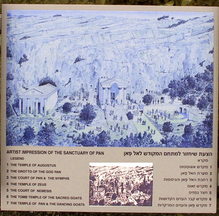
This grotto was considered the "abode of the shepherd god" Pan. Ritual sacrifices were thrown into this natural abyss which reached down to the underground waters fueling these upper springs of the Jordan. If the victim disappeared in the water, this was a sign that the god had accepted the offering. If blood appeared in nearby springs, it was believed that the sacrifice had been rejected.
|
|
Numerous temples were built in this town from the Hellenistic (Greek) period through to Roman times. The early name "Panias" (and variants) directly identifies this location with worship of one pagan Greek god, "Pan". It's later and current name (Banias and Banyas) are merely corruptions of this original, with the "B" later being substituted for the "P", due to usage in the Arabic language. The grotto of Pan was a focal point in the worship of this half-man half-goat, flute playing deity. For at least two centuries before Christ, sacrifices were cast into the cave as offerings to Pan. At that time the main spring emerged from this large cave (... meaning that they drank from this sacrifice infected water afterwards). Earthquakes have since caused the water flow to emerge elsewhere.
The now stagnant waters of the grotto of Pan Near the grotto of Pan a number of niches were carved in the rock cliff. These niches were used to hold idols depicting numerous deities, including Echo, a mountain nymph who was said to be a consort of Pan. Modern churches, with their inscriptions proclaiming the names of donors, have good company in this ancient site. Similar inscriptions provide the names of those who gave large donations to the temples of these gods.
To
the right of the grotto of Pan, numerous niches adorn the rock face
(also below),
|
|
Roman
era bridge still in use with a modern road over it,
Same Roman era bridge from opposite side
|
|
Panium was transferred, by the Romans, to the control of Herod the Great in 20 B.C., who subsequently built a temple there to Caesar Augustus. (Yes, this is the same Herod who professed to be Jewish and paid to rebuild the temple in Jerusalem). Following Herod's death in 4 B.C., his son Philip assumed control of this region. It was he that later renamed the town to Caesarea Philippi, in honor of (Caesar) Tiberius and himself. Shortly before the transfiguration, Jesus and the disciples went north to the region of Caesarea Philippi. The Bible does not say that Jesus actually went into the town, but it does not exclude it either. Certainly there would have been a number of smaller villages in the surrounding countryside. Jesus frequently used parables, or word pictures, to illustrate his message. For this reason, I find it quite likely that the following event took place within sight of Caesarea Philippi itself...
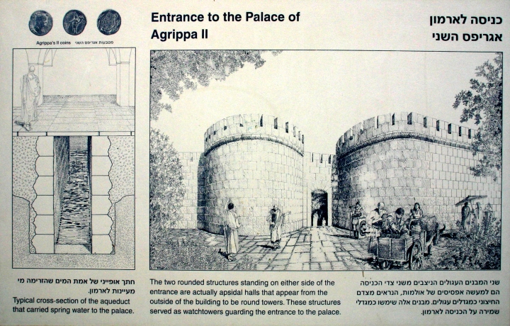
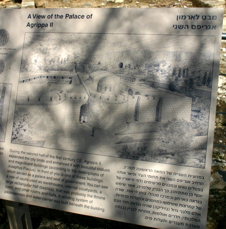
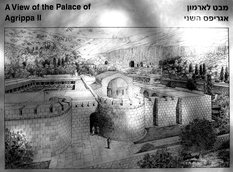
The grotto of Pan and the rock face of the mountain would have made imposing visuals as Jesus declared Himself the Rock on which the church would be built and that the gates of Hell would never prevail against it. (Gates of Hell: think of a Grotto into which a sacrifice would be thrown, which would then be pulled down by the current, into the earth, not to rise again). Clearly these visuals would have driven home Jesus' claim of authority and power. In the years following Jesus' resurrection, a descendant of Herod the Great tried to change the name of the town once again. Herod Agrippa II renamed the city Neronias in honor of Emperor Nero. With Nero's ignoble death by suicide, this name was quickly abandoned, not for the previous Caesarea Philippi but for its' earlier name, Paneas. This Herod Agrippa, who had a large palace at Caesarea Philippi, was the one who Paul appeared before at Caesarea Maritima.
Ruins
of the Herod Agrippa II's palace During the first Jewish revolt (beginning 66 A.D.), the Roman General (and soon to be Emperor) Vespasian camped his army at Paneas. Following the war, his son Titus (and later to be Emperor) held gladiatorial tournaments in the town, slaughtering many Jewish prisoners as entertainment.
This view is to the right of the circular structure in the previous photo
Looking
back toward the circular structure
A corridor in the palace
|
|
An aquaduct runs under the floor of this corridor
Stone missing, showing the waterway underneath
An
overview of about half of the palace. Note the large storage areas
at the rear right
Still more of the palace.
The ancient Cardo (Main Street) of the city
|